At $6,900, GDP per capita is relatively high in Namibia compared to other countries in the region, but the wealth is very unevenly distributed and 56 percent of the population live below the poverty line. Life expectancy in Namibia is only 52 years. This has come down because of Aids/HIV which affects around 15 percent of the population.
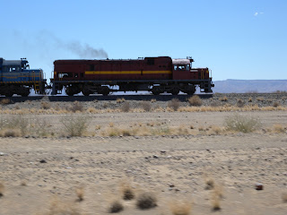
We headed to the very south of Namibia to the Fish River Canyon, which is the second largest canyon in the world after the Grand Canyon. As we drew closer, it felt like we were driving to the end of the world. The scenery is so desolate, but still has this beautiful, ethereal quality. At one point, we found ourselves driving alongside a steam train. There can't be too many places left in the world where that is possible. As our guide slowed down to keep pace, we noticed some children who were hanging out the carriage windows and waving at us.
Before reaching the canyon, we stopped off at the Canon Roadhouse which is a quirky restaurant and lodge that attempts to recreate the sort of roadhouse you might see on the remote parts of Route 66 in the US. There were old, rusted cars in the garden and inside the restaurant and for a moment, I felt like I was back in Cuba. As you drive around Namibia you sometimes see abandoned cars by the side of the road and given the vast distances from civilisation, they are usually just left there to rust. We had our lunch under a tree which provided some welcome shade, before heading back onto the road to seemingly nowhere.
As we drew closer to the canyon, some crevasses in the flat, barren land gave us a hint of what was to come. But nothing could have prepared us for the breathtaking view of the canyon itself, which gouges out the earth to the tune of 160km in length, 27km in width and a depth of 550 metres. There are two viewing platforms at the top of the canyon. Our guide dropped us at the furthest one so we could walk back along the rim to the main platform which offers the most impressive view of the canyon.
It is possible to do a five-day hike through the canyon. Our guide has done this three times with groups of guests. It must be incredibly difficult to not only push yourself to achieve the arduous trek, but also be responsible for guests and even have to carry their bags if they're struggling.
 |
| The path down to the bottom of the canyon |
 |
| I woz ere.. |
 |
| Scenery around the top of the canyon |
Once we'd taken in the stunning spectacle of the canyon itself, we drove down the road which runs alongside it to the southern end of the canyon. It seemed like we were driving into a quarry and was not particularly attractive, but then we turned into the campsite at Ai-Ais which by contrast was a veritable oasis. Aside from the welcome sight of some trees and vegetation, the campsite is right on top of some hot springs. In the Nama language, Ai-Ais means "scalding hot" and with water at 60 degrees celsius, it certainly is. The hot water is rich in chloride, flouride and sulphur and reputedly therapeutic for rheumatism. It's piped into the campsite for baths, jacuzzis and even the swimming pool. After a long day's drive, we took a dip in the pool which felt like swimming in a very large hot bath. I tried doing a few lengths but it was too warm for anything energetic. After a five-day hike through the canyon though, I can imagine that it's somewhere you'd want to spend a lot of time.


No comments:
Post a Comment